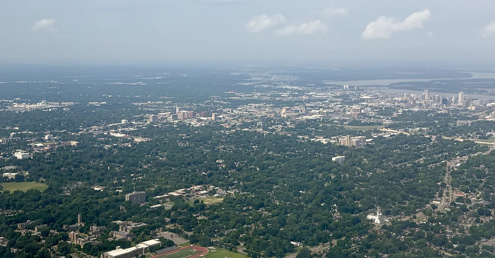
Twelve Memphis areas, from Downtown and Midtown to Cordova and Whitehaven, with ZIP codes, zoned high schools and Zillow home values for September 2026.
Last checked Oct. 18, 2026. Sources: the City of Memphis’s Memphis 3.0 planning districts, district boundary layer and comprehensive plan, 2021 update (PDF); Memphis-Shelby County Schools’ School Zone Locator; the Tennessee Department of Education’s 2024-25 letter grades; Zillow Research; the Census Bureau; and OpenStreetMap. Memphis 3.0 planning office: 901-636-6601.
Memphis is a city of 618,980 people, according to the Census Bureau’s 2020-2024 American Community Survey five-year estimates, almost all of it in Shelby County. The Mississippi River is its west edge. I-40 crosses the north side from the Hernando de Soto Bridge to Cordova, I-240 loops around Midtown and East Memphis, and I-55 runs south through Whitehaven to Mississippi. Memphis International Airport sits in the south-central part of the city.
The city’s own comprehensive plan, Memphis 3.0, divides Memphis into 14 planning districts, each with its own city planner. This guide uses those districts, and the neighborhood names the plan maps inside each one, for 12 areas.
Three things to know before you look at a listing:
- ZIP codes do not follow the city line. Zillow files ZIP codes 38016 and 38018 under Cordova, and about 17% of the Cordova district’s 2020 residents lived outside the city limits; 38133, 38134 and 38135 are filed under Bartlett; and 38125 reaches toward Germantown and Collierville. Check the parcel at the Shelby County Assessor of Property and see our property taxes guide.
- School zones do not follow neighborhood lines. Memphis-Shelby County Schools serves the city and unincorporated Shelby County, and every area here except Frayser crosses two or more high school zones. Check one address in the School Zone Locator.
- Home values vary more than sevenfold by ZIP code. In September 2026 the Zillow Home Value Index ran from $54,692 in 38106 to $422,325 in 38120, and the citywide figure was $151,794, down 2.8% in a year.
The areas at a glance
Home values are the Zillow Home Value Index for the area’s main ZIP code in September 2026, a modeled typical value for the middle third of homes, not a sale price. Zoned high schools are from Memphis-Shelby County Schools’ zone data, weighted by 2020 Census population.
| Area | Main ZIP code | Zoned high school | Typical home value in the ZIP |
|---|---|---|---|
| Downtown and Midtown | 38104 | Mostly Central High | $248,684 |
| North Memphis and Harbor Town | 38107 | Mostly Manassas High | $103,875 |
| Frayser | 38127 | Trezevant High | $86,555 |
| Raleigh | 38128 | Split: Raleigh-Egypt, Craigmont or Kingsbury | $143,481 |
| Cordova | 38016 | Mostly Cordova High | $290,354 |
| University District | 38111 | Split: White Station, Overton or Melrose | $130,811 |
| East Memphis | 38119 | Split: Ridgeway or White Station | $288,176 |
| Orange Mound (Lamar) | 38114 | Mostly Melrose High | $70,758 |
| South Memphis | 38106 | Mostly Hamilton High | $54,692 |
| Whitehaven | 38116 | Split: Hillcrest or Whitehaven | $151,252 |
| Parkway Village and Oakhaven | 38118 | Split: Wooddale, Sheffield or Oakhaven | $120,452 |
| Hickory Hill | 38115 | Mostly Kirby High | $160,944 |
On Tennessee’s 2024-25 letter grades, White Station High and Whitehaven High earned an A; Central, Cordova, Ridgeway, Raleigh-Egypt, Oakhaven, Douglass and Mitchell a B; Craigmont a C; and Trezevant, Manassas, Overton, Melrose, Hamilton, B. T. Washington, Hillcrest, Kirby, Kingsbury, Wooddale and Sheffield a D, in the state’s grade file. The district also runs optional schools that students apply to; see our schools guide.
The map
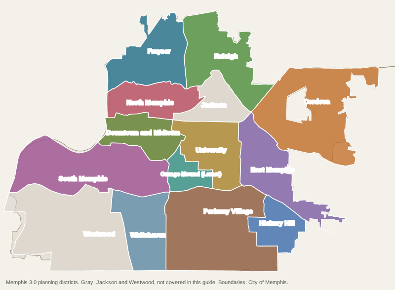
District boundaries are from the City of Memphis’s Memphis 3.0 planning district layer.
The areas
Downtown and Midtown. The Core City District, from the riverfront to East Parkway: Downtown, South Main, the Medical District, Crosstown, Cooper-Young, Central Gardens and Overton Park. About 50,500 residents.
North Memphis and Harbor Town. Harbor Town on Mud Island, Uptown, Hollywood, New Chicago, Klondike and Vollintine Evergreen, north to the Wolf River.
Frayser. The northwest corner between the Wolf and Loosahatchie rivers, all in ZIP code 38127, with Rodney Baber Park and a city golf course.
Raleigh. The northeast side, with Raleigh Town Center on the old Raleigh Springs Mall site and the 690-acre Oakley Park.
Cordova. The largest district by population, along Germantown Parkway, with Wolfchase Galleria and Shelby Farms Park; part of it is unincorporated.
University District. The University of Memphis, High Point, Chickasaw Gardens, Binghampton and the 326-acre Audubon Park.
East Memphis. The office and shopping corridor on Poplar Avenue and the neighborhoods around it, with the highest ZIP code values in this guide.
Orange Mound (Lamar). Orange Mound, Cherokee and Fairhills between Airways Boulevard and Getwell Road, with two branch libraries.
South Memphis. Soulsville and the Stax Museum, French Fort, Riverview and the 350-acre Martin Luther King Jr. Riverside Park.
Whitehaven. Elvis Presley Boulevard and Graceland, all in ZIP code 38116, split between the Hillcrest and Whitehaven high zones.
Parkway Village and Oakhaven. The neighborhoods around Memphis International Airport, which the city’s plan says hold 21% of the city’s jobs.
Hickory Hill. The Southeast District along Winchester Road and Kirby Parkway, mostly zoned for Kirby High.
Not covered yet: the Jackson District (Berclair, Highland Heights, Grahamwood and Mitchell Heights; mostly ZIP code 38122 and the Kingsbury High zone) and the Westwood District (Westwood, Westhaven and Walker Homes; ZIP code 38109, split between Fairley and Westwood high zones, with T.O. Fuller State Park).
Comparing Memphis with its neighbors? See Memphis vs Germantown vs Southaven vs Horn Lake. More in our moving to Memphis, schools, home prices, parks and trails and getting around guides.
How we built this
We listed only areas that the city names and that we could place on a map:
- The City of Memphis’s 14 Memphis 3.0 planning districts and their boundary layer. Each page is one district; neighborhood names come from the asset maps in the city’s 2021 comprehensive plan update, and OpenStreetMap place names, © OpenStreetMap contributors.
- Memphis-Shelby County Schools’ zone data, the layer behind its School Zone Locator, matched to 2020 Census blocks so that each school’s share counts residents, not land; the Tennessee Department of Education’s 2024-25 grade file for grades.
- Census ZIP code areas and 2020 block counts for ZIP codes and population; the Zillow Home Value Index for home values; the city’s parks layer for park names and acreage; MATA’s published schedule data for bus routes; and OpenStreetMap for stores, libraries, interstate exits and road distances.
We picked 12 of the 14 districts; Jackson and Westwood are on the city’s map. Areas are described from public records only. We do not rank them.
Frequently asked questions
What are the main areas of Memphis?
The city’s Memphis 3.0 comprehensive plan divides Memphis into 14 planning districts: Core City (Downtown and Midtown), North, Frayser, Raleigh, Jackson, Cordova, University, East, Lamar (Orange Mound), South, Westwood, Whitehaven, Oakhaven and Parkway Village, and Southeast (Hickory Hill).
Do Memphis ZIP codes match the city limits?
No. ZIP codes 38016 and 38018 are filed by Zillow under Cordova and include unincorporated Shelby County; 38133, 38134 and 38135 are filed under Bartlett; and 38125 runs east toward Germantown and Collierville. A Memphis mailing address does not prove a Memphis tax bill.
Which high school is my Memphis address zoned for?
Memphis-Shelby County Schools assigns schools by address, and zones do not follow neighborhood lines: every area in this guide except Frayser crosses two or more high school zones. Check one address in the district’s School Zone Locator.
What is the typical home value in Memphis?
$151,794 in September 2026, down 2.8% in a year, according to the Zillow Home Value Index. Among the main ZIP codes of the areas in this guide it ranged from $54,692 in 38106 (South Memphis) to $290,354 in 38016 (Cordova).
Have your say